Where Chandapura is
Chandapura is a Town Municipal Council within Anekal taluk, Bengaluru Urban district, on NH-44 (Hosur Road) — coordinates approximately 12.80°N, 77.71°E, PIN 562107. It sits south of Electronic City, feeding the Bommasandra and Jigani industrial belts, and north of Attibele and the Tamil Nadu border. It is an affordable, established, industrial-adjacent Hosur Road node with a functioning residential base, its own retail high street, and a well-known Saturday fresh-produce market.
The defining locational fact is layered transport. Chandapura is one of very few Bengaluru suburbs served by metro, suburban rail, and a national highway at once — and that layering is what underwrites both the daily-living case and the rental thesis.
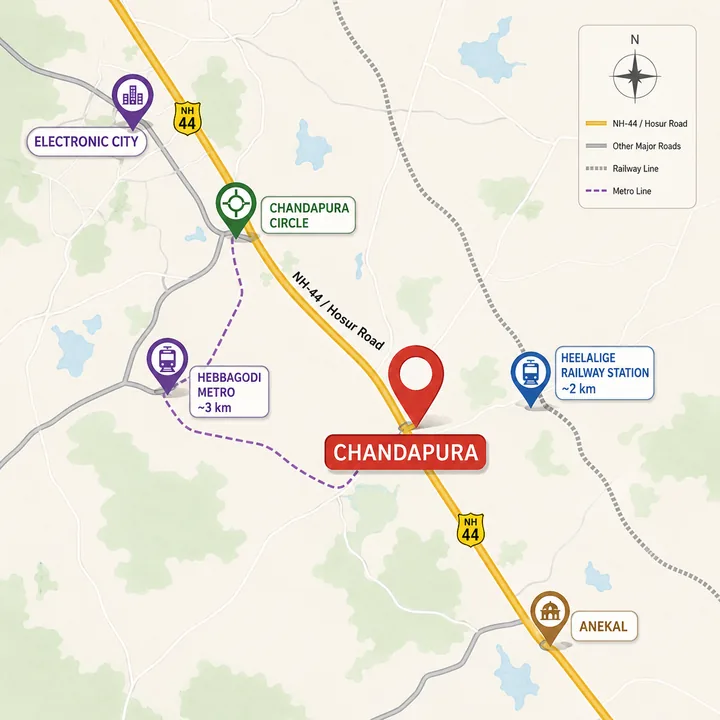
Connectivity at a glance
| Destination | Approx distance | Mode |
|---|---|---|
| Hebbagodi Metro (Yellow Line) — nearest | ~3 km | Namma Metro (operational) |
| Bommasandra Metro (Yellow Line terminus) | ~5 km | Namma Metro (operational) |
| Heelalige railway station | ~2 km | Suburban / passenger rail |
| Electronic City Phase 1 | ~6 km | NH-44 / road |
| Electronic City Phase 2 | ~8–10 km | NH-44 / road |
| Bommasandra Industrial Area / KIADB | ~5 km | Road |
| Attibele | ~8 km | NH-44 |
| Jigani Industrial Area | ~8–10 km | Road |
| Silk Board (via Yellow Line) | ~18–20 km | Metro corridor |
| Kempegowda International Airport | ~55–60 km | NH-44 / Elevated corridor / ORR |
Metro — the Yellow Line changes the story
The single biggest recent shift for this belt is the Namma Metro Yellow Line (RV Road ↔ Bommasandra), which is operational. It connects the Hosur Road corridor directly into the wider metro network via Silk Board and BTM Layout. For Chandapura, Hebbagodi station is the nearest access, roughly 3 km away, and the Bommasandra terminus is around 5 km.
This matters because it converts Chandapura from a road-only suburb — historically hostage to NH-44 congestion — into a market with a rapid-transit alternative. A commuter can drive or take a feeder to Hebbagodi and ride the Yellow Line into the city, bypassing the worst of the road bottlenecks. For a value-segment buyer or a tenant, operational metro access at ~3 km is a material, present-tense advantage that most affordable Bengaluru markets do not offer.
Rail — Heelalige suburban access
Heelalige railway station is approximately 2 km from Chandapura, on the Bengaluru–Hosur line. Suburban and passenger rail gives the belt a second mass-transit option — useful for travel toward the city, toward Hosur, and along the Tamil Nadu corridor. Very few Bengaluru residential nodes have a railway station within 2 km; it is a genuine differentiator for Chandapura and a useful redundancy against road congestion.
Road — NH-44 and the STRR arc
NH-44 (Hosur Road) is the arterial spine. It runs north toward the Electronic City elevated expressway and the city core, and south toward Attibele, Hosur, and Tamil Nadu. The Electronic City elevated corridor eases the E-City stretch considerably.
The Satellite Town Ring Road (STRR) — the outer ring linking Bengaluru's satellite towns — passes through the nearby Anekal / Attibele belt. The Hoskote–Tamil-Nadu-border stretch is targeted to open around mid-2026, which will improve peripheral connectivity and freight movement across the South-East arc, and add another layer of regional access to the Chandapura belt.
The honest caveat on road: Chandapura Circle is a known congestion pinch-point, especially around the Saturday market. This is the trade-off of an established, high-footfall node. The mitigations are real — the Yellow Line metro and Heelalige rail both provide congestion-independent routes — but a buyer should factor peak-hour road delay into their commute planning.
Employment — a very large base within a short radius
Chandapura's rental and end-user demand is anchored by one of Bengaluru's densest employment corridors.
| Hub | Approx distance | Character |
|---|---|---|
| Electronic City Phase 1 | ~6 km | Infosys, Wipro, HCL — flagship IT |
| Electronic City Phase 2 | ~8–10 km | Infosys' largest campus, Biocon, Tech Mahindra, TCS, Siemens, HP |
| Bommasandra Industrial Area / KIADB | ~5 km | Manufacturing, pharma, hardware |
| Jigani Industrial Area | ~8–10 km | Manufacturing and logistics |
| Attibele Industrial Area | ~8 km | Manufacturing |
This concentration — IT at Electronic City and manufacturing at Bommasandra, Jigani, and Attibele — generates deep, diversified tenant demand. It is not dependent on a single sector or a single employer, which makes the rental base more resilient than markets that ride one campus. For an investor, that diversification is the quiet strength of the Chandapura location.
Schools & colleges
| Institution | Approx distance |
|---|---|
| Alliance University (Engineering & Management) | ~4 km |
| Sri Chaitanya School | ~5 km |
| Narayana Group schools | ~4–5 km |
| Sorsfort International School (E-City side) | ~5–7 km |
| VIBGYOR High, Electronic City | ~7 km |
| IFIM / ISBR / XIME business schools (E-City) | ~7–9 km |
Surana, Nazareth, St. Philomena's, and other schools serve the immediate locale. The presence of Alliance University at ~4 km and a strong cluster of CBSE and international schools on the Electronic City side means education infrastructure is genuinely established — a key factor for the young-family buyer.
Hospitals
| Hospital | Approx distance |
|---|---|
| Narayana Health City / Narayana Hrudayalaya (Bommasandra) | ~5–7 km |
| Sparsh Hospital (Bommasandra / Infantry area) | ~5–8 km |
| Springleaf Hospital, Electronic City | ~6–7 km |
| Kauvery Hospital, Electronic City | ~7 km |
| Vimalalaya Hospital | ~5 km |
Narayana Health City at Bommasandra is a major tertiary-care anchor within 5–7 km — a significant reassurance for families. Local nursing homes and clinics along the Chandapura–Hebbagodi stretch cover primary care within 2–4 km.
Retail & daily life
Everyday and lifestyle retail is well covered: Neo Mall (Electronic City, ~7 km), M5 E-City Mall, SBR Lucky Mall, and Star Bazaar and high-street retail along Hosur Road, alongside Chandapura's own Saturday fresh-produce market. The mix of organised mall retail on the E-City side and local high-street and market retail on the doorstep means a resident rarely needs to travel far for daily needs.
The airport reality
Kempegowda International Airport is on the far north side of the city — approximately 55–60 km from Chandapura via NH-44 and the ring-road / elevated corridors. This is not an airport-corridor location, and we do not pitch it as one. For a South-East Bengaluru value-node, airport distance is a normal trade-off; the location's strength is its employment access and multi-modal transit, not aviation adjacency.
Commute scenarios — what daily life looks like
To translate the distance table into lived experience, consider a few typical residents.
An IT professional at Electronic City Phase 1 (~6 km). The commute is a short drive up NH-44, eased by the Electronic City elevated corridor, or a feeder-plus-metro combination via Hebbagodi on the Yellow Line. Either way, this is one of the shortest work commutes available to an Electronic City employee at a value price — a decisive advantage over living further into the city and battling the full Hosur Road stretch daily.
A manufacturing or pharma employee at Bommasandra or Jigani (~5–10 km). Bommasandra is close and well-connected by road, with the Bommasandra metro terminus at ~5 km as an alternative. Jigani is a straightforward road commute. For the industrial workforce, Chandapura is a natural residential base — close, affordable, and serviced.
A city-bound commuter. The Yellow Line at Hebbagodi (~3 km) connects to Silk Board, BTM, and the wider network, offering a congestion-independent route into the city core — a genuine option that road-only suburbs cannot match.
A rail commuter. Heelalige station (~2 km) provides suburban-rail access toward the city and along the Hosur line — a further redundancy that few Bengaluru nodes offer.
The pattern across all of these is the same: Chandapura's multi-modal access makes a wide range of commutes short and resilient, which is exactly what underpins both the end-user appeal and the rental demand.
Social infrastructure depth
What separates Chandapura from a frontier location is the depth of social infrastructure already in place. Alliance University at ~4 km anchors higher education; a strong cluster of CBSE, ICSE, and international schools on the Electronic City side covers school-age families; Narayana Health City at Bommasandra provides tertiary care within ~5–7 km; and organised mall retail (Neo Mall, M5, SBR Lucky Mall) plus local high-street and market retail cover everyday and lifestyle needs. This is a suburb that already functions as a complete place to live — not a residential island waiting for services to arrive.
Location verdict
Chandapura's location case is about present-tense maturity and multi-modal access. Operational metro at ~3 km, suburban rail at ~2 km, NH-44 as the road spine, a very large and diversified employment base within 5–10 km, and established schools, hospitals, and retail — all at a price point below the corridor's premium pockets. The one honest weakness, Chandapura Circle congestion, is materially offset by the metro and rail alternatives. For a value-segment buyer, this is a genuinely strong location — and it is the reason a Prestige community here would make sense. Distances are approximate and for the Chandapura locality; precise site coordinates and the sanctioned location map will follow an official launch. See the overview for the full value thesis and the price page for the cost model. Prestige Rosewood is useful inside the same prestige-group Bengaluru set because buyers still need to separate developer familiarity from address, layout, and payment-plan fit.
Prestige Chandapura location FAQ
Where exactly is Prestige Chandapura located?
At Chandapura, a Town Municipal Council within Anekal taluk, Bengaluru Urban district, on NH-44 (Hosur Road) — approximately 12.80 degrees North, 77.71 degrees East, PIN 562107. It sits south of Electronic City, feeding the Bommasandra and Jigani industrial belts, and north of Attibele and the Tamil Nadu border.
Which is the nearest metro station to Prestige Chandapura?
Hebbagodi on the Namma Metro Yellow Line (RV Road to Bommasandra) is the nearest access at approximately 3 km; the Bommasandra terminus is around 5 km. The Yellow Line is operational and connects the corridor into the wider network via Silk Board and BTM Layout.
Is there railway access near Prestige Chandapura?
Yes. Heelalige railway station is approximately 2 km away, on the Bengaluru–Hosur line, giving suburban and passenger-rail access. Very few Bengaluru residential nodes have a railway station within 2 km.
How far is the employment base from Prestige Chandapura?
Electronic City Phase 1 is approximately 6 km, Electronic City Phase 2 around 8–10 km, Bommasandra Industrial Area / KIADB about 5 km, Jigani around 8–10 km, and Attibele about 8 km — a very large, diversified IT-and-manufacturing employment base within a short radius.
What is the main connectivity drawback at Chandapura?
Chandapura Circle is a known congestion pinch-point, especially around the Saturday market. The operational Yellow Line metro and Heelalige rail both provide congestion-independent routes, but a buyer should factor peak-hour road delay into their commute planning. The airport, at approximately 55–60 km, is also distant.
Ask about Prestige Chandapura's location
Register your interest for verified project-location details, the sanctioned location map, and directions as soon as they are released for Prestige Chandapura, Hosur Road, South-East Bengaluru.
Contact us